Community Corner
UPDATES: FOX RIVER OVERFLOWING; EVACUATIONS Encouraged, More on Roadways Flooding; 6-8 Inches Collecting in Some Areas
The Fox River is overflowing its banks, flooding area basements and streets near the basin. The sewer system is backed up, Tri-Com says.


Reports of the Fox River flowing over banks and retention walls, flooded basements and one fire, quickly put out, are deluging Tri-Com dispatch Thursday morning.
Related Articles
- Rainfall Totals in Chicago Suburbs
- St. Charles Flooding: What You Need to Know
- Patch Readers Share Flash Flood Photos
- Gov. Quinn Declares a State of Emergency
National Weather Service Forecast
- Thursday Night: Showers likely and possibly a thunderstorm before 8pm, then a chance of showers. Mostly cloudy, with a low around 37. Breezy, with a west southwest wind 15 to 20 mph, with gusts as high as 30 mph. Chance of precipitation is 60%. New rainfall amounts of less than a tenth of an inch, except higher amounts possible in thunderstorms.
- Friday: A 40 percent chance of showers. Cloudy, with a high near 46. Breezy, with a west wind 20 to 25 mph, with gusts as high as 30 mph.
8 p.m.
Find out what's happening in Genevawith free, real-time updates from Patch.
- Gov. Pat Quinn Declares a State of Emergency
6:30 p.m.
Find out what's happening in Genevawith free, real-time updates from Patch.
Updated Flood Closure/Disruption
- Water on the pavement on East Main Street (800-900 block) but the road remains open.
- Flooding on the north side of East Main Street in the construction zone; also, there are no culverts on the temporary driveways/streets, and material may wash away.
- Standing water on Route 31 north of Main Street in front of Carroll Towers.
- Water has spilled over the river bank into the north parking lot at the Municipal Building.
- Pedestrian Bridge at Indiana Avenue is closed.
Opened/Opening Soon*
Assuming no additional rainfall:
- Tyler Road at the railroad crossing.
- Sections of Illinois Avenue between 7th and 13th avenues are open, as well as the adjacent streets.
Remaining Closed
- State Street from Route 31 to 3rd Street.
- The Illinois Street/Avenue Bridge.
- The Park District has closed Boy Scout Island.
- The Department of Natural Resources has restricted boating on the Fox River
3:14 p.m
Tri-Com reports vehicle collision at Fabyan and Mill Creek. Two or three vehicles, minor damage.
3 p.m.
St. Charles Closures, Restrictions
- Tyler Road is closed at the railroad crossing.
- Sections of Illinois Avenue between 7th and 13th avenues are closed, as well as some adjacent streets.
- The Illinois Bridge is closed.
- The Park District has closed Boy Scout Island.
- The Department of Natural Resources has restricted boating on the Fox River.
- 2:57 p.m.— Southbound Route 31 closed north of Main Street.
- 2:57 p.m.— Ferson Creek Park closed.
- Fox Riverwalk is closed.
- Rising waters have restricted parking in the city's parking lot immediately north of the St. Charles Municipal Center.
West Chicago
The city of West Chicago also announced road closures and restrictions related to flooding:
- Route 38 (Roosevelt Road) — Joliet Street to Wegner.
- Town Road — Forest Avenue to Route 38.
- Downs Drive — Kress Road to Industrial Drive.
- Arbor Avenue at Hawthorne Lane.
- Ingalton Avenue at Hawthorne Lane.
2 p.m. EVACUATE IF YOU LIVE NEAR LOW-LYING AREA
From Kane County Sheriff's Department, Pat Gengler:
Due to the heavy rains over the past 24 hours Kane County is experiencing flooding along the Fox River, local creeks and other low lying areas. Sandbagging efforts are underway along the Fox River in the Valley View area north of St Charles, South Elgin, Algonquin and Dundee area. River levels are expected to rise over the next few days. Anyone living along the low lying areas near the river area encouraged to make plans to evacuate should water levels continue to rise. Areas that are already flooded will only get worse. Fire and Law enforcement personnel encourage people not to wait until they need to be rescued to make the decision to move to higher ground.
- For those citizens who live in incorporated municipalities they should call their local authorities for sandbags. Those living in unincorporated areas should call (630) 208-8911.
- We also want to remind people that driving through flooded roadways can be dangerous.While you may think the roadway is passable the water tends to be deeper than you thinkand can hide hazards that can disable your car in the middle of the flooded roadway.
- Many media outlets have asked for a list of flooded roadways in the Kane County area. We do not have a detailed list but when one is available the detailed list will bedistributed.
11:30 a.m.
The Illinois St bridge in St Charles is closed according to Tri-Com. Posted on Facebook 9:30 a.m.
Tabatha RenchGeneva East subdivision has sewage backup (800 block). Spent over 4 hours holding it off while it was coming up into my basement. Posted on Facebook 11:20 a.m.
From city of Geneva 10:45 a.m.:
Most recent road closures:
- Kautz and Geneva Drive
- River Lane near Fulton/Franklin
- Lewis Road
- Merchants Drive south of Fargo
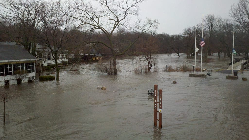
- Island Park is under water.
- Dodson Street at Park Street has standing water in the roadway.
- Dip in the southbound land of Randall Road on the north side of the Randall Road bridge seems to be getting worse.
City Crews currently are pumping at the following locations:
- Manchester
- Short St.
- Fargo & Batavia Ave.
- Pine & Sherman
- Peppervalley & Northampton
10 a.m.
Batavia:
Batavia Weather, from the weather service at public works.
Fox River closed to boating, IDNR Web Site.
Due to high water and strong currents caused by the heavy rains, the Illinois Department of Natural Resources has issued an order closing the Fox River to boat traffic as of 3:00 PM on Wednesday, April 17. Navigating the river is extremely hazardous and must be avoided.
Geneva:
Flooded roadways in Geneva, courtesy of the city of Geneva website, as of 9:15 a.m.:
We have several roads that are flooded and should be avoided if possible.
- Merchants Drive at the Fire Station #2 pond
- Kautz Rd. north of Averill
- River lane at Franklin
- Rt 31 near Peck
- Geneva Dr. near Eastside Dr.
- Island Park is under water.
- Dodson Street at Park Street has standing water in the roadway.
- Dip in the southbound land of Randall Road on the north side of the Randall Road bridge seems to be getting worse.
Geneva crews currently are pumping at the following locations:
- Manchester
- Short St.
- Fargo & Batavia Ave.
- Pine & Sherman
- Peppervalley & Northampton
As of 8 a.m. Thursday morning, more than 3.25 inches of rain was reported at Ferson Creek, with more rain expected through the day. The Fox River level reads at 19 feet, 1 inch in St. Charles. The flood stage for the river is 18 feet, 3 inches.
“Crews worked throughout the night to close off flooded streets and answer emergency calls,” said Brian Townsend, City Administrator. “So far there have been no power outages, just a few momentary power disruptions. In neighborhoods where excessive flooding has occurred, city personnel are assisting homeowners.”
There are areas of localized flooding, particularly near 7th Avenue creek. Sandbags have been delivered to the area for residents to help. “It is important to remember that the stormwater system is designed to handle moderate to heavy rain events. This event is extreme and is taxing systems across the region,” said Townsend. Also sandbags are available at the City’s Public Works facility, 200 Devereaux Way.
To report flooding in a particular area, call 630-377-4435.You also could report it on the St. Charles Connect interactive tool either through the City website or by downloading the new mobile app from your mobile device. For emergencies, call 911.
Information updates will be posted, as necessary, on the City website,www.stcharlesil.gov, the City’s Facebook page, www.facebook.com/CityofStCharlesand Twitter, twitter.com/cityofstcharles . You also can tune into 780 AM on the radio, or watch your local television stations.
St. Charles Flood Closures
- Tyler Road is closed at the railroad crossing
- Sections of Illinois Avenue between 7th and 13th avenues are closed, as well as some adjacent streets
- The Illinois Bridge is closed
- The Park District has closed Boy Scout Island
- The Department of Natural Resources has restricted boating on the Fox River
9 a.m.
Some area units reporting to Lisle—not sure why. Tri-Com.
Please TEXT photos to 630-886-0792 or email rickn@patch.com.
@PatchGeneva for Twitter.
National Weather Service-Chicago Flood Warning:
- FLOOD STAGE IS 13.0 FEET.
- MINOR FLOODING IS OCCURRING AND MODERATE FLOODING IS FORECAST.
- FORECAST...THE RIVER WILL CONTINUE RISING TO NEAR 14.9 FEET BY FRIDAY AFTERNOON.
NWS-C Flash-Flood Warning:
In place until noon Thursday, April 18.
- A VERY SERIOUS AND POTENTIALLY DANGEROUS FLOOD SITUATION IS UNDERWAY.
- FLOODING HAS BEEN REPORTED IN MANY BASEMENTS AND HOMES...COUNTLESS ROADWAYS ARE REPORTED UNDER WATER AND IMPASSIBLE. PORTIONS OF THE EISENHOWER...EDENS...AND KENNEDY EXPRESSWAYS HAVE BEEN FLOODED AND CLOSED.
- SOME COMMUNITIES HAVE DECLARED STATES OF EMERGENCY.
- THIS IS A DANGEROUS AND POTENTIALLY LIFE THREATENING FLOODING EVENT. IF YOU DO NOT NEED TO TRAVEL THIS MORNING...STAY HOME.
- PLEASE DO NOT EVEN CONSIDER DRIVING INTO AREAS WHERE WATER COVERS THE ROAD...YOU MAY NOT KNOW HOW DEEP THE WATER IS AND THE ROAD MAY HAVE BEEN WASHED OUT. DO NOT RISK YOUR LIFE...TURN AROUND...DON'T DROWN!
- PRECAUTIONARY/PREPAREDNESS ACTIONS... DO NOT UNDERESTIMATE THE POWER OF FLOOD WATERS. ONLY A FEW INCHES OF RAPIDLY FLOWING WATER CAN QUICKLY CARRY AWAY YOUR VEHICLE.
7 a.m.
Paul Ruby of the Herrington Inn in Geneva is making an urgent plea for help to pile sandbands and save the landmark building.
Kane County is under a Severe Thunderstorm Warning until 8:15 a.m.
Tri-Com reports the sewer systems are filled.
There is flash flooding of a number of streets in low-lying areas, especially on Route 25 and Route 31 between Elgin and Aurora, but the hard downpour around 7 a.m. saw water running down the State Street hill so fast that the right lane was flooded.
Patch will continue to report throughout the day, but we ask your help. If you see or hear of any flooding, dangerous roadways, power outages or other situations, please report in the comments field of this article, comment on the Geneva Patch Facebook page, email rickn@patch.com or text 630-886-0792.


